The Pinchot Trail Chronicle, Part 12
Monday June 28, 2010

[GPS readings would later show that we had covered 7.6 miles to our lunch stop]
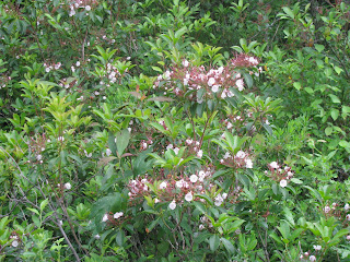
1:40pm - We leave our lunch stop and go south on the Behler Swamp Trail. This trail also runs along the border of the state forest, and is of different character than most of what we have been hiking through. The ever-present mountain laurel is still around, but the trail is rockier, has more roots, is wetter, and very often tunnels through beautiful large stands of rhododendrons, some of which are in bloom.

The rhodos bloom in various shades of white, pink and light purple. The groves are perhaps 20 feet tall in places. We also pass through small stands of evergreens, mostly spruce I believe. We are passing through generally swampy ground, and that coupled with the intermittent showers that continue to follow us make the ground more slippery. I can feel my knee more and more as we move south. It has gone from a periodic twinge to a pretty much non-stop soreness. Nothing horrible yet, but I am aware of it all the time now.

1:59pm - We come out of the rhodo thickets and into a very large evergreen grove. It is dry and spongy here because of the thick carpet of pine needles. On the far side of the grove we join the Tanner road, another dirt and gravel forest service road that is probably mostly used by hunters in season. It is not nearly as pretty to be walking along a road rather than a trail, but the nice even footing gives a welcome respite from the need to be constantly watching your every step to make sure you don't trip over a rock or root hidden by the undergrowth. We are more tired now, and are hiking in wet boots. Continually brushing our way through wet undergrowth has made the rain water run down our legs, soak our socks, and wick down into our boots. Dave comments on the unpleasant squishing sound he is making with every step.
2:16pm - After a quarter mile of road, we duck back into the forest for a quarter mile, and then join the road again for almost a half mile. This section of road is a long gradual upslope, and going up actually gave my knee a bit of a rest. I know from day hiking that downhill is the worst on the knees, with level and uphill (within reason) not being nearly as bad.

2:26pm - We reach the top of the slope and the small grass parking lot for the Choke Creek Nature Trail. There are no cars, but this is where we turn south again and head back into the forest for the duration of the day. I figure we have done over 9 miles at this point [GPS later says 9.4] and I have no great desire to do another step, but there is no mention of camp sites between here and Choke Creek. Also, one of the main reasons for planning the hike the way we did was to camp on the banks of the creek. So we grit our teeth and move on. I am periodically complaining about my knees, and it is both knees now. The right is pretty bad and the left has joined in. I know I am not the only one feeling the effects of our effort, as there are mumbles from my companions as well. I'm probably the most vocal though.

My discomfort was taking some of the fun out of things by now, but there were still pretty sights to see along the way, including bright orange salamanders, mountain laurels in bloom, and more rhododendrons than I had ever seen before. But, over the next few miles I do have to admit that my ability to see anything good pretty much evaporated. I was hot, wet, sweaty, sore, tired, and my knees had both pretty much turned into a burning throbbing mess. Others were mentioning sore feet as their main complaint, but my feet were either fine or my knees hurt so badly that I couldn't feel anything else.

2:45pm - We are still on this damned trail with no end in sight. We are certainly over 10 miles by now, and every time I think we are getting close to dropping down into the stream valley, the trail does some crazy switchback that adds steps. Every step counts at this point, and I am counting every painful one of them.

3:05pm - Finally! We reach the point where we begin to descend toward the stream. I am happy we are getting close, but the descent is agony. As I write this four days later, I have to stop and think about whether agony is really the right word, or if I am overstating for effect. But no, I am convinced that agony is the right word. Dave is beat. "All used up" I think is the phrase he used. I'm a wreck. Leo is the quietest of the three. Suffering in silence, or maybe not suffering, I'm not sure. The only bit of comic relief at this point was the teasing Leo's cell phone was giving him. I never lost my Verizon signal pretty much the whole time we were out, but Leo got about 5 seconds of reception per hour, just enough for his phone to recognize that it had missed calls and text messages, beep a couple of times and then die again before Leo could get it out of his pocket.
3:12pm - I hear water!
Next...finding camp and crashing.
No comments:
Post a Comment