The target date for this day trip was Wednesday 10/28, but a rainy weather forecast had us push to Thursday. Leo would need to be done by about 1:30, but if we got an early enough start, or if Dave and I took a separate car, we would be fine. As it turned out, one of Dave's girls came down with the flu on Wednesday, so we found out Wednesday night that Dave couldn't make it. Leo and I decided to soldier on alone.
The final plan was to meet at a convenience store parking lot just east of Reading at 8:15 or 8:30, then ride together to Hawk Mountain, arriving at around 9:30. This would give us 4 hours for hiking and bird watching.
The Trip
The meet and the drive up went off without a hitch, and we were in the parking lot by shortly after 9:30. Very few cars were in the lot, presumably due to the gray overcast day. Temperatures were in the low 50's with a nice stiff breeze, so the wind chill on the ridges must have been in the 40's. Dressed properly, it felt fine, although a lightweight pair of gloves wouldn't have been bad for the first part of the day.
First stop was the visitor center where I purchased a $40 family membership that will be good until spring of 2011. I could have done a one-day for $5, but it seemed like a good idea to support the Sanctuary by buying more than I will probably need... Sometimes it is about more than the money, and I am fortunate in many ways, so I want to try to support some of these organizations, like the Appalachian Trail Conservancy and the Keystone Trails Association.

[Me on South Lookout (showing my best side - the back of my head!)]
Leaving the visitor center and heading up the short trail to the South Lookout, there are a few people around, but not many. At the South Lookout, we are the only ones there other than a HMS intern from Palestine, who is friendly and chats with us for a little while. Not many birds thus far, and no other people for the moment. The weather is interesting in that there is a completely unbroken gray cloud ceiling as far as the eye can see in every direction with no sun whatsoever. Under the cloud ceiling, there is tremendous visibility, and we can see for many many miles (more than the apparent haze in the photos would indicate).


[View from South Lookout. South slope of Kittatinny Ridge on the left, northern slope of Pinnacle on the right. "Donat" (?) in the center distance. The River of Rocks are the gray spots in the middle of the valley. The bottom of the picture gives some idea of how far the valley drops away from the ridge.]
After maybe 10 minutes at the South Lookout, we set out for the North Lookout, where we arrived after a slight detour to the overlook called "the Slide". It is decidedly breezy here at 1521 feet exposed elevation. There is only one other pair of people here, along with an intern from Argentina and the official spotter, an HMS research biologist. We sit and chat with the intern for a bit. The only bird activity is a few scattered sightings way off in the distance. The biologist, with the aid of many years of experience and a high powered scope, calls out "Golden Eagle on the south slope of 1". In Hawk Mountain terms, the view along Kittatinny Ridge to the east shows 5 distinct bumps, numbered for ease of reference 1 (south) through 5 (north). The Pinnacle is on the far south side of the view east, and "Donut" is a small mountain on the far side of the middle of the valley in between "1" and Pinnacle. In layman's terms, the golden eagle siting could best be describe to the naked eye as "tiny black speck on the horizon moving from left to right." But hey, technically I saw a Golden Eagle, right?

[Official spotting post on North Lookout. Pinnacle visible on the right in the distance.]
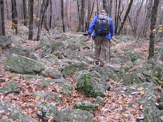
I am a little worried about my knee flaring up at this point, but wandering over to the east face of the North Lookout and seeing the climb down the rock face to get to the Skyline Trail, I can't resist, and we set off climbing down onto the trail labelled as "most difficult" on the trail map. After reaching the bottom of the climb, we set off east on the Skyline Trail, which I find to be a lot of fun because of the broken ground and all the rock hopping. The photos below show the view back up the climb down from North Lookout, as well as a typical stretch of trail on the ridge top, with the ever-present rocks and boulders.


After a short time on the Skyline Trail, we take a right on the Golden Eagle connector trail heading south and drop steeply down into the valley. At one point during our descent, we stop in a boulder filled gully and can hear the unmistakeable sound of running water. A mountain stream is under our feet, buried in the ground under the rocks. We cannot see it, but due to the amount of rain over the last couple of days, we can clearly hear it. At the bottom of the connector trail, we turn left on the River of Rocks trail and head east. Our goal is to do the shorter of the two RoR loops, cutting across between the two large boulder fields and then heading back up the ridge (west then north) to South Lookout.

[The River of Rocks. Geology cool beyond words for a Flatlander like me.]

[The River of Rocks. Geology cool beyond words for a Flatlander like me.]
The River of Rocks trail was a delight, with more of the never ending rocks, chipmunks, a grove of small white pines (only 6-8 feet tall), and of course the River of Rocks itself. Standing out amongst the boulders, we could hear the underground stream again. By now we didn't have a whole lot of extra time, so we headed back uphill to the South Lookout. On the way, there were many beautiful things to see, including a mature thicket of 12-15' tall Rhododendrons.

[Rhododendron thicket.]

[Rhododendron thicket.]
The final ascent of the ridge was the hardest part of the day, although not bad in the overall scheme of things. It was really the only time I felt winded and felt a burn in my thighs. A highlight of the climb was a nicely crafted stone stairway built into the hillside, which was a lot of effort for somebody at some time in the past.
When we got back to South Lookout, we sat and watched for birds for another 10-15 minutes, but then had to go.
Afterthoughts
Riding home in the car afterwards, I am more excited than ever. It was a very bad bird watching day, but being outdoors in general was terrific, and the hiking was great. The knee that bothered me at Ridley Creek last weekend gave me absolutely no trouble at all, and I pushed it much harder today than I did then, with all the climbing and rock-hopping. From a physical standpoint, nothing bothered me at all. Feet, ankles, legs, knees, hips; all were perfectly fine. My gear seems fine, and the additional clothing I have bought for moisture wicking, layering, etc have all proven their worth already. Most importantly, I am perhaps not in as bad physicial shape as I might have guessed. I certainly do not have the cardio conditioning or the leg stamina for steep climbs that I would like to have, but frequent rests can help with that, and if I keep this up it will get better over time. I am fairly confident that I can hold my own on day trips of this nature.
This fulfills Goal #2 for 2009 - go to Hawk Mountain. I am actually getting some things done! Now I need a few more goals for the rest of this year...
Sounds like a great day, and I'm very sorry I couldn't be there. Let's do this, or something like it, again - and soon!
ReplyDeleteOne correction: I'm almost certain that the little hill in the valley is "Donat".
ReplyDeletePossible (and realistic) hiking goals for 2009:
* 10-mile A.T. leg
* Pine Barrens
* White Clay Creek
* Kelly's Run (Susquehanna overlooks)
* Elk Neck State Park
Topo maps of the area call this bump Spitzberg Hill. Further south and east of Pinnacle there is another hill called Spitzenberg Hill. No maps refer to a Donat (or whatever) although that is definitely what the interns referred to is as...
ReplyDelete